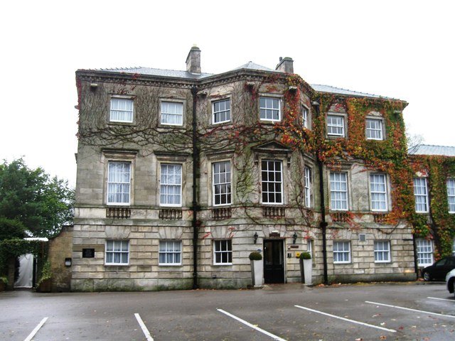



Location: Aughton, Yorkshire
Places / associated places: Aughton, Yorkshire
Location & Extent
GPS Location & Recorded Land Areas
Representative GPS point: 53.8397, -0.9351
Identity: confirmed — The manor is the East Riding Aughton manor now represented by Aughton Hall. The supplied Sandbeck Park archive leads match the Aughton estate records: the 1683 rental, 1685 tenant covenant, 1721 Earl of Castleton will and 1731 survey are specifically identified as records of the Manor of Aughton. The manor-house site is the moated medieval complex at Aughton Hall beside All Saints Church, not the separate Aughton in Aston-cum-Aughton, South Yorkshire.
Representative point: 53.8397, -0.9351
Basis: documented_manor_house — Aughton Hall stands within the medieval moated manorial complex immediately east of All Saints Church. Historic England identifies the complex at OS grid reference SE 70268 38659; the returned decimal point is a suitably rounded WGS84 position for the documented manor-house/site complex.
Point confidence: high
Boundary status: representative_point_only
Boundary period: Documented medieval/early sixteenth-century extent, evidenced by the 1531 inquisition post mortem
Boundary confidence: medium
Boundary basis: The surviving evidence establishes an extensive manorial estate but does not provide a sufficiently precise, mappable perimeter. The 1531 Aske inquisition describes the Manor of Aughton with 30 messuages, approximately 1,000 acres of land and rent in Aughton, Laytham, Goodmanham and West Cottingwith. Other estate material refers to associated lands in Aughton and Ellerton, including Redding Grange, named closes, meadow, fishery and former Ellerton Priory property. These textual holdings cannot safely be converted into a manor polygon without a surviving manor map, survey plan or parcel-level reconstruction explicitly defining the boundary.
Sources:
- The National Archives: Aughton Manor registry record F236338: https://discovery.nationalarchives.gov.uk/details/c/F236338 — Registry record supplied for the exact manor, with authority/reference GB/NNAF/M167023.
- Aughton Hall History: https://e-voice.org.uk/ellertonandaughton/assets/documents/aughton-hall-history-pdf — Identifies the 1683 rental as a rental of the Manor of Aughton; the 1685 covenant with tenants; the 1721 will transferring Aughton Manor to Thomas Lumley; and the 1731 survey including Aughton Manor.
- Hull History Centre: Papers of the Aske family of Aughton, U DX55: https://catalogue.hullhistorycentre.org.uk/files/u-dx55.pdf — The historical background identifies the Aske family as lords of Aughton. The 1531 inquisition summary records the Manor of Aughton with 30 messuages, 1,000 acres of land and rent in Aughton, Laytham, Goodmanham and West Cottingwith.
- Historic England: Motte and bailey castle, fishpond and moated site north and east of Aughton church, Ellerton, list entry 1007973: https://historicengland.org.uk/listing/the-list/list-entry/1007973 — Places the documented medieval manorial complex at SE 70268 38659, states that Aughton Hall stands within the bailey, and describes the associated motte, baileys, moats, fishponds and relationship to All Saints Church.
- Ellerton & Aughton Halls: https://e-voice.org.uk/ellertonandaughton/history/ellerton-aughton-halls/ — States that Aughton Hall stands on the site of the moated house belonging to the Aske family and identifies it as the surviving hall associated with Aughton Manor.
Warnings / uncertainty:
- The historical manor is confirmed as Aughton in the East Riding of Yorkshire, now within Ellerton parish; it should not be conflated with Aughton in Aston-cum-Aughton, South Yorkshire.
- No reliable source located supplies a complete, georeferenced boundary for the manorial land. The 1,000-acre textual extent includes land in several settlements and is not equivalent to the modern civil-parish boundary.
- The representative point identifies the documented manor-house/manorial-centre site and is safe for point injection, but no manor-territory polygon should be injected.
Records & References
Sources and references mentioning this manor/title which are not necessarily conveyances or transfers.
5 records found · showing 1–5.
1731: survey, with other manors
Held by: Sandbeck Park
Further information: NRA 6155 Lumley
1685: agreement between lord and tenants rel to payment of rents
Held by: Sandbeck Park
Further information: NRA 6155 Lumley
1683: rental
Held by: Sandbeck Park
Further information: NRA 6155 Lumley
1609-1613: court rolls (2)
Held by: Sandbeck Park
Further information: NRA 6155 Lumley
1514: court roll
Held by: Sandbeck Park
Further information: NRA 6155 Lumley
Corrections / Challenges
Sign in to challenge or submit evidence against a recorded assertion.
JSON API
Machine-readable published manor data, including public images, mapped land areas, notes, rights, conveyances, relationships, records, source/document-library entries and public file links.
https://manorialregistry.com/index.php?rest_route=/mhr/v1/manor/aughton-manorPublic API access is currently disabled. Authorised API clients must use a private X-MHR-API-Key; currently only administrator keys are enabled.
Private source files, pending edits, moderation/admin information, user API keys and non-public import identifiers are not returned.