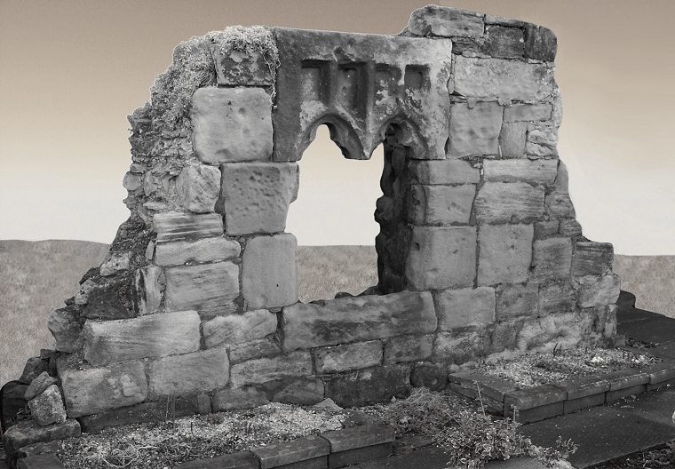



Historical names: Ambell (Manor)
Location: Warkworth, Northumberland
Places / associated places: Warkworth, Northumberland
Location & Extent
GPS Location & Recorded Land Areas
Representative GPS point: 55.3331, -1.5883
Identity: confirmed — The registry record's primary name AMBLE and alias Ambell match the Northumberland Archives manor-history file and contemporary historical accounts for the manor of Amble/Ambell in the parish of Warkworth, Northumberland. The associated 1608 rental and survey with Hauxley, and later descriptions of the Amble estate, corroborate this identification.
Representative point: 55.3331, -1.5883
Basis: documented_manor_house — The former manor house, also called Ambell Hall, stood in the historic settlement of Amble. Its surviving remains are incorporated into or lie immediately beside the present Sacred Heart and St Cuthbert church site on Hallbank Lane, off High Street. The point is an approximate WGS84 position for the documented manor-house site, based on the church/Hallbank Lane location and the surviving manor-house remains.
Point confidence: medium
Boundary status: representative_point_only
Boundary period: Medieval period to the eighteenth century, with estate components documented particularly in 1608, 1742 and 1798
Boundary confidence: none
Boundary basis: The surviving evidence establishes an extensive but geographically dispersed manorial holding rather than a single recoverable perimeter. The 1742 inquisition describes the manor or lordship of Amble together with the Amble and Hauxley coal mines, salt pans at Amble, a free warren at Amble and Hauxley, four farms at Hope House in Amble, two farms at Hauxley Fields, a burgage house and garth with four stints in Warkworth, and three farms plus a coney warren at Togston Moor Houses, also called Low Hall. The 1798 grant similarly refers to the manor and its lands, hereditaments and appurtenances in Amble, Hauxley and Warkworth. These textual descriptions do not provide enough mapped parcel or boundary information to reconstruct a defensible historical polygon, and the Northumberland Archives manorial map explicitly states that it shows manor locations, not their extents.
Sources:
- Northumberland Archives, Manor History File: Amble: https://northumberlandarchives.com/wp-content/uploads/2025/01/Manor-History-File-AMBLE.pdf — Identifies the manor as Amble, alias Ambell, in the Tynemouth lordship; records its historical ownership, manorial connections with Hauxley and Warkworth, and the relevant 1608–1900 archival records.
- Taking Stock: Amble – Sacred Heart and St Cuthbert: https://taking-stock.org.uk/building/amble-sacred-heart-and-st-cuthbert/ — States that the church site on Hallbank Lane includes the site of the former manor house and that small manor-house remains survive in the garden south of the church.
- The History of Amble and District: https://www.fusilier.co.uk/amble_and_district_mcandrews/amble_northumberland_history.htm — Describes the old manor house as being in the street of Ambell and gives the historical estate components, including Hope House, Hauxley Fields, Warkworth interests and Togston Moor Houses.
- The History of the Township Amble, Northumberland: https://www.fusilier.co.uk/amble_northumberland/town-history.htm — Quotes the 1653 description of Ambell Hall and the 1742 inquisition listing the manor's lands, rights and properties in Amble, Hauxley, Warkworth and Togston Moor Houses.
- Northumberland Archives, Manorial Map project: https://northumberlandarchives.com/manorial-project/manorial-map/ — Confirms that the county manorial map shows the situation of proven manors but not their extent or boundaries.
- The National Archives: Amble manor record F282248: https://discovery.nationalarchives.gov.uk/details/c/F282248 — Registry record supplied for the exact manor identification, associated with Warkworth, Northumberland and authority GB/NNAF/M305515.
Warnings / uncertainty:
- The representative point is for the documented manor-house site, not the centre of the entire manorial holding.
- No defensible historical manorial boundary polygon was found. The manor comprised dispersed lands and rights in Amble, Hauxley, Warkworth and Togston Moor Houses; a modern parish, township or civil-parish boundary would be an invalid substitute.
About the Manor
A manor associated with Amble, in the parish of Warkworth, Northumberland.
Records & References
Sources and references mentioning this manor/title which are not necessarily conveyances or transfers.
8 records found · showing 1–8.
1840-1840: plan
Held by: Northumberland Archives
1820-1820: plan
Held by: Northumberland Archives
1800-1900: map
Held by: The National Archives
1743-1744: particulars (2)
Held by: The National Archives
1629-1629: survey, with other manors
Held by: Northumberland Archives
1618-1618: particular
Held by: The National Archives
1608-1608: survey, with Hauxley
Held by: The National Archives
1608-1608: rental, with Hauxley
Held by: The National Archives
Corrections / Challenges
Sign in to challenge or submit evidence against a recorded assertion.
JSON API
Machine-readable published manor data, including public images, mapped land areas, notes, rights, conveyances, relationships, records, source/document-library entries and public file links.
https://manorialregistry.com/index.php?rest_route=/mhr/v1/manor/amblePublic API access is currently disabled. Authorised API clients must use a private X-MHR-API-Key; currently only administrator keys are enabled.
Private source files, pending edits, moderation/admin information, user API keys and non-public import identifiers are not returned.