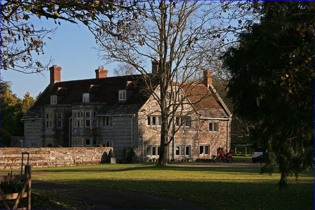



Location: Almer, Dorset
Places / associated places: Almer, Dorset
Location & Extent
GPS Location & Recorded Land Areas
Representative GPS point: 50.79091, -2.1234
Identity: confirmed — The registry record is securely identified with the historic Almer Manor in Almer, Dorset. Dorset Heritage Explorer and Historic England identify the surviving Grade II* house as Almer Manor, formerly West Almer Farm, at OS National Grid reference SY 9140 9897/SY 9140298970. The supplied TNA and Dorset History Centre court-roll references are manorial records for the same Almer manor context.
Representative point: 50.79091, -2.12340
Basis: documented_manor_house — The surviving Almer Manor house, a c.1600 building with early seventeenth-century extensions, at the documented site corresponding to SY 9140 9897 / SY 9140298970.
Point confidence: high
Boundary status: representative_point_only
Boundary period:
Boundary confidence: none
Boundary basis: Reliable sources establish the manor house and the historical association of Almer parish and Mapperton with the manor, including nineteenth-century descriptions naming Drax as lord of the manor and sole landowner. However, no manor-specific map, survey, rental plan, explicit metes-and-bounds description, or scholarly reconstruction was located that would justify a historical manorial polygon. The former parish boundary, conservation-area boundary, modern estate boundary, and the reported parish acreage cannot safely be substituted for the manor's territorial extent.
Sources:
- Almer Manor, Almer, Sturminster Marshall — Dorset Heritage Explorer, MDO27070: https://heritage.dorsetcouncil.gov.uk/Monument/MDO27070 — Identifies Almer Manor, formerly West Almer Farm; dates the surviving house to about 1600 with early seventeenth-century extensions; gives grid reference SY 9140 9897 and the parish/location context.
- Almer Manor — Historic England list entry 1120056: https://historicengland.org.uk/listing/the-list/list-entry/1120056 — Authoritative listing identifying the Grade II* Almer Manor and its National Grid Reference SY 9140298970.
- Almer Conservation Area — Dorset Council supplementary planning guidance: https://www.dorsetcouncil.gov.uk/documents/35024/287469/SPG01%2BAlmer%2BConservation%2BArea.pdf — Describes the architectural and landscape setting of Almer Manor and its relationship to West Almer Farm, but does not define a manor boundary.
- Almer — GENUKI, transcribing the National Gazetteer of Great Britain and Ireland, 1868: https://www.genuki.org.uk/big/eng/DOR/Almer — States that Almer parish contained Mapperton and that T. S. Drax was lord of the manor; useful contextual evidence but not a manor-specific boundary survey.
- Almer Genealogy Resources & Parish Registers — Forebears, reproducing Kelly's Directory of Dorset, 1895: https://forebears.io/england/dorset/almer — Reports that Erle-Drax was lady of the manor and sole landowner, and gives the parish area as 1,161 acres including Mapperton; this supports context but is insufficient to reconstruct the manorial perimeter.
- TNA/MDR record F245511 — Almer Manor: https://discovery.nationalarchives.gov.uk/details/c/F245511 — The supplied National Archives manor authority record for the exact registry entry.
- Dorset History Centre court roll, 1420, D.788/M1: https://discovery.nationalarchives.gov.uk/details/r/N14368085 — Supplied archival lead for an Almer manor court roll.
- Dorset History Centre court roll, 1469, D.788/M2: https://discovery.nationalarchives.gov.uk/details/r/N14285479 — Supplied archival lead for an Almer manor court roll, held with records of other manors.
- Dorset History Centre court roll, 1522, D.788/M3: https://discovery.nationalarchives.gov.uk/details/r/N14256474 — Supplied archival lead for an Almer manor court roll.
- The National Archives, SC 2/169/10, courts with other manors and Cogdean hundred, 1539–1545: https://discovery.nationalarchives.gov.uk/details/r/N14366328 — Supplied archival lead for sixteenth-century manorial court material involving Almer and associated manors.
- Drax private collection, D.S./Manor/7, court roll, 1602–1692: https://discovery.nationalarchives.gov.uk/details/r/N14288865 — Supplied archival lead for later Almer manor court material in the Drax/Plunkett-Ernle collection.
Warnings / uncertainty:
- No defensible historical manorial polygon was found in the accessible evidence.
- The representative point identifies the documented surviving manor house, not the full historic manor extent.
- The historic Almer parish, its 1,161-acre nineteenth-century area, the Almer Conservation Area, and the Charborough/Drax estate must not be treated as interchangeable with the medieval or early-modern manor boundary.
Records & References
Sources and references mentioning this manor/title which are not necessarily conveyances or transfers.
5 records found · showing 1–5.
1602-1692: court roll
Held by: Collection held privately: enquiries to The National Archives, Archives Sector Leadership
Further information: NRA 9218 Plunkett-Ernle
1539-1545: courts with other manors and Cogdean hundred
Held by: The National Archives
1522-1522: court roll
Held by: Dorset History Centre
1469-1469: court roll, with other manors
Held by: Dorset History Centre
1420-1420: court roll
Held by: Dorset History Centre
Corrections / Challenges
Sign in to challenge or submit evidence against a recorded assertion.
JSON API
Machine-readable published manor data, including public images, mapped land areas, notes, rights, conveyances, relationships, records, source/document-library entries and public file links.
https://manorialregistry.com/index.php?rest_route=/mhr/v1/manor/almer-manorPublic API access is currently disabled. Authorised API clients must use a private X-MHR-API-Key; currently only administrator keys are enabled.
Private source files, pending edits, moderation/admin information, user API keys and non-public import identifiers are not returned.