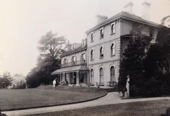



Location: Wandsworth, Surrey
Places / associated places: Wandsworth, Surrey
Location & Extent
GPS Location & Recorded Land Areas
Representative GPS point: 51.45353, -0.18572
Identity: confirmed — The TNA/MDR record, Wandsworth location, associated places, and the archive references correspond to the historic manor of Allfarthing in Wandsworth and Battersea. The 1640 Surrey History Centre map is explicitly catalogued as a map of the Manor of Allfarthing, Wandsworth and Battersea; the manor was also historically known as Allfarthing Finches and Barking Fee.
Representative point: 51.45353, -0.18572
Basis: documented_manor_site — The former Allfarthing manor house stood facing Allfarthing Lane between historic Church Lane, now St Ann's Crescent, and The Grove, now St Ann's Hill. Local historical research places the manor-house/farm site approximately at or immediately adjacent to the present Allfarthing Primary School site on St Ann's Crescent. The point supplied is the documented school/site coordinate and should be treated as an approximate manor-house-site representative point rather than a surviving building location.
Point confidence: medium
Boundary status: representative_point_only
Boundary period: Surveyed 1633; map copy dated 1640, with later references continuing into the nineteenth century
Boundary confidence: medium
Boundary basis: The 1640 Gardner/Porter map provides direct historical evidence that the manor extended across parts of Wandsworth and Battersea. Described features include the Wandle as a natural estate boundary, the Thames-side Wandsworth settlement, the gravel ridge forming the northern edge near the line of modern Lyford Road, Heathfield Road and Wandsworth Common West Side, Garratt Green and Burnt Wood, and the detached or projecting approximately 40-acre Allfarthing Piece on Wandsworth Common, later associated with the Toast Rack area. These sources establish the manor's historical territorial pattern but do not provide sufficient accessible georeferenced boundary data to reconstruct a defensible polygon without inventing vertices.
Sources:
- The Manor of Allfarthing, Wandsworth and Battersea: Map, Surrey History Centre, ref. 3991: https://www.exploringsurreyspast.org.uk/collections/getrecord/SHCOL_3991 — Archive catalogue entry for the 1640 manor map; identifies Allfarthing as a manor in Wandsworth and Battersea and records its ownership history.
- All-farthing/Half-farthing on an early map: https://historyofwandsworthcommon.org/chronicles/02/02-2025.html — Identifies the 1633 survey and 1640 copy of the Gardner/Porter map, locates the manor house between St Ann's Crescent and St Ann's Hill, and describes the Wandle, ridge, Garratt Green, Burnt Wood and Allfarthing Piece as mapped manor features.
- Wandsworth Historical Society: previous talks reports: https://www.wandsworthhistory.org.uk/talks/previous_talks_reports_2022.htm — Summarises the 1640 map as showing Allfarthing Manor and Wandsworth Common, including the approximately 40-acre Allfarthing Piece and the mapped fields, lanes and landscape features.
- Wandsworth Town Conservation Area London Borough of Wandsworth Historic Area Assessment: https://historicengland.org.uk/research/results/reports/5829/WandsworthTownConservationAreaLondonBoroughofWandsworthHistoricAreaAssessment — Confirms that the historic parish of Wandsworth was divided into four manors, including Allfarthing, and reproduces discussion of the Peter Gardner 1640 map.
- Allfarthing Primary School location: https://mapcarta.com/W142287815 — Provides the coordinate used as an approximate representative point for the documented manor-house/site location near present-day Allfarthing Primary School.
Warnings / uncertainty:
- No reliable georeferenced polygon or complete coordinate transcription of the 1640 manor map was located.
- The representative point is approximate and derives from the documented historic manor-house location and its reported correspondence with the present Allfarthing Primary School site.
- The historical manor extent must not be substituted with the modern Wandsworth parish, borough, ward, conservation-area or postcode boundary.
About the Manor
A manor or manorial estate associated with Wandsworth, historically in Surrey.
Records & References
Sources and references mentioning this manor/title which are not necessarily conveyances or transfers.
22 records found · showing 1–8.
1820: valuation, with other manors
Held by: Hampshire Archives
Further information: NRA 5307 Wood
1800-1900: custumal, with other manors
Held by: Surrey History Centre
Further information: NRA 3518 Surrey RO misc
1800: survey (with bounds)
Held by: Hampshire Archives
Further information: NRA 5307 Wood
1710-1927: court books (6)
Held by: Northamptonshire Archives Service
1640: map
Held by: Surrey History Centre
1621-1622: rental, with Battersea
Held by: The National Archives
1609-1610: survey
Held by: The National Archives
1609-1610: rental
Held by: The National Archives
Corrections / Challenges
Sign in to challenge or submit evidence against a recorded assertion.
JSON API
Machine-readable published manor data, including public images, mapped land areas, notes, rights, conveyances, relationships, records, source/document-library entries and public file links.
https://manorialregistry.com/index.php?rest_route=/mhr/v1/manor/allfarthing-manorPublic API access is currently disabled. Authorised API clients must use a private X-MHR-API-Key; currently only administrator keys are enabled.
Private source files, pending edits, moderation/admin information, user API keys and non-public import identifiers are not returned.