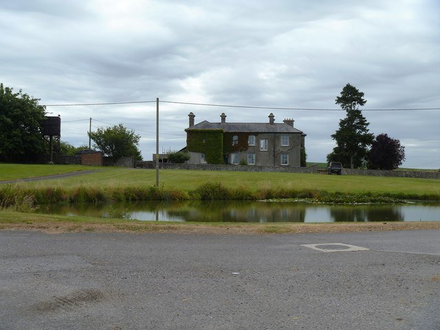



Location: All Cannings, Wiltshire
Places / associated places: All Cannings, Wiltshire
Location & Extent
GPS Location & Recorded Land Areas
Representative GPS point: 51.353484, -1.901461
Identity: confirmed — The TNA/MDR record F273005 is explicitly for All Cannings Manor in All Cannings, Wiltshire. Local historical sources identify the same manor as the medieval and post-Dissolution manor of All Cannings, formerly held by the Abbey of St Mary, Winchester, and later by Edward Seymour and the Nicholas and Baring families. The archival leads concern All Cannings manor accounts, court rolls, rentals and admissions.
Representative point: 51.353484, -1.901461
Basis: documented_manor_house — The surviving manor house is identified with Manor Farm, The Street, All Cannings. Local and historical sources describe the manor house as a 14th-century building, now a farmhouse. The coordinate is the published geolocation for postcode SN10 3PF, which contains Manor Farm, and should be treated as an approximate building/site point rather than a surveyed doorway coordinate.
Point confidence: medium
Boundary status: representative_point_only
Boundary period: Medieval to early modern; later documented through the 1799 enclosure context
Boundary confidence: none
Boundary basis: The evidence establishes the manor house and indicates that Fullaway was historically part of All Cannings Manor. The 1799 enclosure abstract records the All Cannings and Fullaway area under the Lord of the Manor of All Cannings and lists numerous named fields, but the accessible evidence does not provide a sufficiently explicit, georeferenced perimeter of the manorial land. The ancient parish and later civil-parish boundaries cannot safely be substituted for the manor boundary, and the evidence does not conclusively establish that every part of the wider historic parish, including Allington, belonged to this manor.
Sources:
- The National Archives Discovery: All Cannings Manor, TNA/MDR F273005: https://discovery.nationalarchives.gov.uk/details/c/F273005 — Registry record identifying the exact manor as All Cannings Manor in Wiltshire.
- Wiltshire Community History: All Cannings: https://apps.wiltshire.gov.uk/communityhistory/Community/Index/3 — States that the area was a former royal and Winchester estate, describes the manor-related history, identifies Manor Farm as the large historic farm, and discusses the historic settlements and enclosure of open fields.
- A Vision of Britain through Time: All Cannings, Wiltshire: https://www.visionofbritain.org.uk/place/11650 — Describes the All Cannings manor-house as a 14th-century building now used as a farmhouse and gives the historic parish context.
- Wiltshire OPC Project: All Cannings parish history: https://www.wiltshire-opc.org.uk/parishes/all-cannings/ — Identifies the surviving manor house as a farmhouse with 14th-century woodwork and confirms the historic association of Allington and Fullaway with the parish.
- Wiltshire Community History: Fullaway and All Cannings Manor: https://apps.wiltshire.gov.uk/communityhistory/Question/Details/475 — Explicitly states that Fullaway was part of All Cannings Manor in medieval times and describes Fullaway Farm and its persistent historic boundaries.
- Abstracts of Wiltshire Inclosure Awards: All Cannings, 1799: https://www.wiltshire-opc.org.uk/Items/All%20Cannings/All%20Cannings%20-%20Inclosure%20Awards%20Abstract%201799.pdf — Records the 1799 All Cannings and Fullaway enclosure context, the Lord of the Manor of All Cannings, the stated area, and numerous named fields and land divisions.
- SN10 3PF postcode geodata: https://www.getthedata.com/postcode/SN10-3PF — Provides the coordinate 51.353484, -1.901461 for SN10 3PF, the postcode containing Manor Farm, The Street, All Cannings.
Warnings / uncertainty:
- The representative coordinate is a postcode-level approximation for the documented manor-house site, not a precise surveyed coordinate for the historic building.
- No defensible historical manorial polygon was found in the accessible evidence.
- Do not substitute the modern All Cannings civil-parish boundary or the ancient parish boundary for the manor extent.
- Fullaway is securely associated with All Cannings Manor in the cited local historical evidence; the extent of the manor beyond the documented core and Fullaway remains unresolved.
- The 1799 enclosure field list is evidence of historical land divisions but does not by itself provide enough georeferenced boundary information to construct a safe polygon.
About the Manor
A manor associated with the parish and village of All Cannings in Wiltshire.
Records & References
Sources and references mentioning this manor/title which are not necessarily conveyances or transfers.
5 records found · showing 1–5.
1730-1783: surrenders and admissions
Held by: Wiltshire and Swindon History Centre
1710-1710: rental (in bundle with other papers)
Held by: Wiltshire and Swindon History Centre
Further information: NRA 1335 Wilts Soc
1615-1619: court rolls (4), with other manors
Held by: Wiltshire and Swindon History Centre
Further information: NRA 30725 Brudenell-Bruce
1518-1530: court rolls, with Urchfont
Held by: Wiltshire and Swindon History Centre
Further information: NRA 30725 Brudenell-Bruce
1449-1527: accounts
Held by: Wiltshire and Swindon History Centre
Further information: NRA 30725 Brudenell-Bruce
Corrections / Challenges
Sign in to challenge or submit evidence against a recorded assertion.
JSON API
Machine-readable published manor data, including public images, mapped land areas, notes, rights, conveyances, relationships, records, source/document-library entries and public file links.
https://manorialregistry.com/index.php?rest_route=/mhr/v1/manor/all-cannings-manorPublic API access is currently disabled. Authorised API clients must use a private X-MHR-API-Key; currently only administrator keys are enabled.
Private source files, pending edits, moderation/admin information, user API keys and non-public import identifiers are not returned.