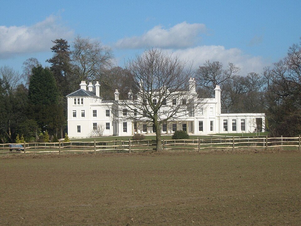



Location: Ashurst, Kent
Places / associated places: Ashurst, Kent
Location & Extent
GPS Location & Recorded Land Areas
Representative GPS point: 51.1336, 0.1881
Identity: confirmed — The National Archives registry record and the associated Kent archival series identify a Manor of Ashurst in Ashurst, Kent. The Royal Tunbridge Wells/Kent Historic Landscape Characterisation study independently discusses the medieval Manor of Ashurst, its demesne, wood pasture, water mill, appendant lands and association with Ashurst Plain or the parkland around the later Ashurst Place/Fernchase Manor. This distinguishes it from other Ashurst manors in Surrey, Sussex and elsewhere.
Representative point: 51.1336, 0.1881
Basis: supported_manorial_centre — The point is the documented site of Fernchase Manor, formerly Ashurst Place on Ordnance Survey mapping and later renamed Ashurst Manor. The historic landscape study places the likely medieval Ashurst wood-pasture/demesne landscape around Ashurst Plain and the parkland surrounding this site. Historic England records the building at National Grid Reference TQ 53189 39424.
Point confidence: medium
Boundary status: representative_point_only
Boundary period: Medieval to early modern; best documented spatial evidence relates to the 1268 manorial description and later estate/manorial records from 1575-1820.
Boundary confidence: none
Boundary basis: The available web evidence establishes components and approximate setting but not a defensible perimeter of the manorial land. The 1268 inquisition records 120 acres of arable land, 47 acres of pasture, 40 acres of wood pasture, a water mill, rents and the advowson; the study suggests the wood pasture may correspond to Ashurst Plain or the later parkland around Fernchase Manor. It also records appendant or associated lands including Buckland and Rodmaredge/Groombridge. The surviving catalogue descriptions of the 1575 survey, rentals and court rolls do not expose parcel lists or mapped boundaries online. The later Ashurst Park estate boundary is not automatically the medieval manor boundary and therefore has not been substituted.
Sources:
- The National Archives: Ashurst Manor, TNA/MDR record F287561: https://discovery.nationalarchives.gov.uk/details/c/F287561 — Registry record for ASHURST MANOR, located at Ashurst, Kent, authority/reference GB/NNAF/M313609.
- Kent Historic Landscape Characterisation: Parish of Speldhurst: https://tunbridgewells.gov.uk/__data/assets/pdf_file/0004/387679/p-HLC_Speldhurst.pdf — Discusses Ashurst as a medieval manor; records its appendant lands, the 1268 inquisition with 120 acres of arable, 47 acres of pasture, 40 acres of wood, a water mill and other manorial resources; suggests the wood pasture may correspond to Ashurst Plain or the parkland around Fernchase Manor.
- Historic England: Fernchase Manor, list entry 1240499: https://historicengland.org.uk/listing/the-list/list-entry/1240499 — Officially identifies Fernchase Manor, formerly Ashurst Place on Ordnance Survey mapping, at TQ 53189 39424 in Ashurst Park, Speldhurst, Kent.
- Ashurst Park, Parks & Gardens UK: https://www.parksandgardens.org/places/ashurst-park — Places Ashurst Park approximately 2 km north-east of Ashurst village, identifies the mansion and parkland, and records the historic estate context, including the 1843 tithe map and later park boundaries.
- FamilySearch catalogue: Manorial records, 1661-1820; Manor of Ashurst: https://www.familysearch.org/en/search/catalog/646401 — Catalogues the Kent Archives Office material as manorial records of the Manor of Ashurst, including court and estate records for 1661-1820.
Warnings / uncertainty:
- The representative point is a supported manorial/estate-centre proxy, not a proven surviving medieval manor-house site.
- The present Ashurst Manor/Fernchase Manor building is an early nineteenth-century house; its use as the representative point is based on the documented historical association of Ashurst Place/Ashurst Park with the Ashurst manorial landscape, not on architectural survival from the medieval period.
- No historical manor boundary polygon was found that can be safely reconstructed from the accessible evidence.
- Do not substitute the modern civil parish, the later Ashurst Park estate, or the present property boundary for the historical manorial extent.
- The manor had associated or appendant lands outside the immediate Ashurst settlement area, including Buckland and Rodmaredge/Groombridge, so its legal extent may not have been a single compact polygon.
Records & References
Sources and references mentioning this manor/title which are not necessarily conveyances or transfers.
41 records found · showing 25–32.
1686-1686: court roll (copy undated, early 19th cent) (in volume with other items)
Held by: Kent History and Library Centre
1686-1686: rental (in roll with other items)
Held by: Kent History and Library Centre
Further information: NRA 7219
1686-1686: court roll (in roll with other items)
Held by: Kent History and Library Centre
Further information: NRA 7219
1686-1686: names of tenants, with quit rents
Held by: Kent History and Library Centre
1680-1680: estreats (in roll with other items)
Held by: Kent History and Library Centre
Further information: NRA 7219
1680-1680: rental (in roll with other items)
Held by: Kent History and Library Centre
Further information: NRA 7219
1680-1680: court roll (in roll with other items)
Held by: Kent History and Library Centre
Further information: NRA 7219
1680-1680: court roll (copy undated, early 19th cent) (in volume with other items)
Held by: Kent History and Library Centre
Corrections / Challenges
Sign in to challenge or submit evidence against a recorded assertion.
JSON API
Machine-readable published manor data, including public images, mapped land areas, notes, rights, conveyances, relationships, records, source/document-library entries and public file links.
https://manorialregistry.com/index.php?rest_route=/mhr/v1/manor/ashurst-manor-3Public API access is currently disabled. Authorised API clients must use a private X-MHR-API-Key; currently only administrator keys are enabled.
Private source files, pending edits, moderation/admin information, user API keys and non-public import identifiers are not returned.