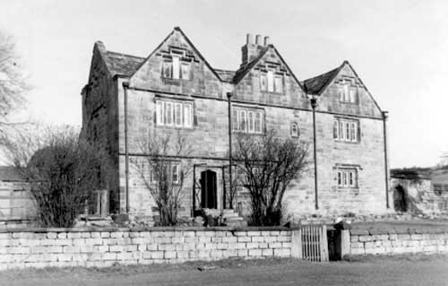



Location: Harewood, Yorkshire
Places / associated places: Harewood, Yorkshire
Location & Extent
GPS Location & Recorded Land Areas
Representative GPS point: 53.867047, -1.544438
Identity: confirmed — The National Archives catalogue identifies the 1682 map record LF/M53 as created by ALWOODLEY MANOR, and the associated 1689 perambulation, 1712 and 1735 boundary maps, court files, call rolls and rental are all held in the Lane Fox archive series for the same manor. The registry location at Harewood is consistent with Alwoodley historically being a township in Harewood parish. This is the Alwoodley manor centred on Alwoodley Old Hall, not the separate Harewood manor or Harewood House estate.
Representative point: 53.867047, -1.544438
Basis: documented_manor_house — Site of Alwoodley Old Hall, the late-medieval/early-modern manor house and seat of the Frank family, formerly beside the south side of Eccup Reservoir. Historic England records the site at OS grid reference SE3006041272; the Gazetteer of British Place Names gives WGS84 coordinates 53.867047,-1.544438.
Point confidence: high
Boundary status: representative_point_only
Boundary period: 1682-1773 evidence survives in the cited archive series, with a specifically recorded 1689 perambulation and 1712 boundary map
Boundary confidence: none
Boundary basis: The catalogue confirms that historical maps and written boundary/perambulation records survive for Alwoodley Manor, but the accessible catalogue pages do not expose the mapped perimeter or the detailed boundary text. No defensible historical polygon can therefore be reconstructed from the available web evidence. The modern Alwoodley civil-parish boundary must not be substituted for the manorial boundary.
Sources:
- The National Archives: LF/M53, 1682 map of Alwoodley Manor: https://discovery.nationalarchives.gov.uk/details/r/N14272795 — The record is held by West Yorkshire Archive Service, Leeds; its record creator is explicitly ALWOODLEY MANOR and the date is 1682.
- The National Archives: GB/NNAF/M170453 / F244162, Alwoodley Manor authority record: https://discovery.nationalarchives.gov.uk/details/c/F244162 — Registry authority record for the exact manor supplied by the user.
- The National Archives: LF/129/7, 1689 description of boundary as perambulated: https://discovery.nationalarchives.gov.uk/details/r/N14311461 — Confirms that a contemporary written perambulation of the Alwoodley Manor boundary survives in the same archive series.
- The National Archives: LF/117/4, 1712 map of boundary: https://discovery.nationalarchives.gov.uk/details/r/N14325764 — Confirms survival of a dedicated historical map of the manor boundary.
- The National Archives: LF/117/5, 1735 map of Alwoodley Manor: https://discovery.nationalarchives.gov.uk/details/r/N14370711 — Confirms a further eighteenth-century manor map in the same collection.
- Historic England Archive: Alwoodley Old Hall, card 6707_023: https://historicengland.org.uk/images-books/photos/englands-places/card/407598 — Identifies Alwoodley Old Hall at Alwoodley, Leeds and gives OS grid reference SE3006041272.
- Alwoodley Parish Council: Alwoodley History: https://www.alwoodleyparishcouncil.gov.uk/your-community/alwoodley-history/ — States that Alwoodley was historically a collection of farms in Harewood parish, that Alwoodley Old Hall was the area's large late-medieval house and seat of the Frank family, and that the hall was demolished in 1969.
- Gazetteer of British Place Names: Alwoodley Old Hall: https://gazetteer.org.uk/place/Alwoodley_Old_Hall,_Yorkshire_299565 — Provides the historical site classification and WGS84 coordinates 53.867047,-1.544438 for Alwoodley Old Hall.
Warnings / uncertainty:
- The representative point is the documented site of the former manor house, not a surviving building.
- The historical manorial extent remains unpolygoned because the cited archive maps and the detailed 1689 perambulation are catalogued but their geographic content is not available in the accessible web records.
- Do not use the modern Alwoodley civil-parish, electoral-ward or Harewood Estate boundaries as substitutes for the historical manor boundary.
About the Manor
A historic manor associated with Alwoodley, north of Leeds, in the West Riding of Yorkshire and within the wider Harewood area.
Records & References
Sources and references mentioning this manor/title which are not necessarily conveyances or transfers.
13 records found · showing 9–13.
1735: map
Held by: West Yorkshire Archive Service, Leeds
Further information: NRA 15 Lane Fox
1729-1742: court file
Held by: West Yorkshire Archive Service, Leeds
Further information: NRA 15 Lane Fox
1712: map of boundary
Held by: West Yorkshire Archive Service, Leeds
Further information: NRA 15 Lane Fox
1689: description of boundary as perambulated
Held by: West Yorkshire Archive Service, Leeds
Further information: NRA 15 Lane Fox
1682: map
Held by: West Yorkshire Archive Service, Leeds
Further information: NRA 15 Lane Fox
Corrections / Challenges
Sign in to challenge or submit evidence against a recorded assertion.
JSON API
Machine-readable published manor data, including public images, mapped land areas, notes, rights, conveyances, relationships, records, source/document-library entries and public file links.
https://manorialregistry.com/index.php?rest_route=/mhr/v1/manor/alwoodley-manorPublic API access is currently disabled. Authorised API clients must use a private X-MHR-API-Key; currently only administrator keys are enabled.
Private source files, pending edits, moderation/admin information, user API keys and non-public import identifiers are not returned.