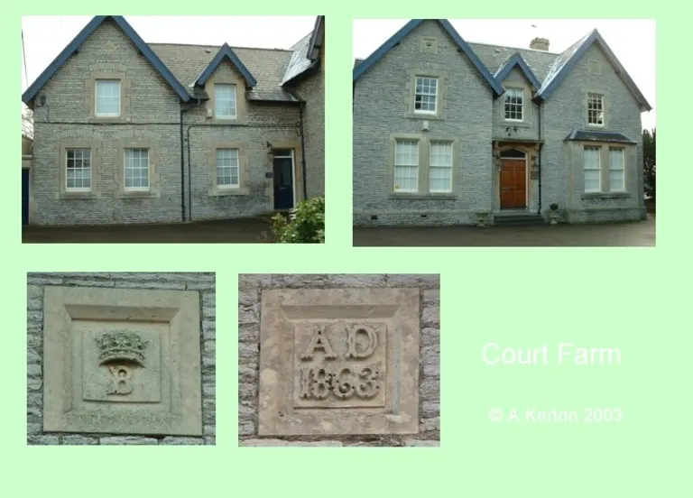



Historical names: Ailmondestrey (Manor) | Alesborowe (Manor) | Amsbury (Manor)
Location: Almondsbury, Gloucestershire
Places / associated places: Almondsbury, Gloucestershire
Location & Extent
GPS Location & Recorded Land Areas
Representative GPS point: 51.55456, -2.57488
Identity: confirmed — The registry record, historical forms, Almondsbury location, and associated Gloucestershire Archives/Bristol Archives manorial records identify the principal manor of Almondsbury, distinct from the separate manors or tithings of Gaunt's Earthcott, Over, Hempton and Patchway, Lea, and Tockington. The medieval manor house was Court Farm in the village of Almondsbury. After the manor passed from St Augustine's Abbey to secular ownership, the Chester family established Knole Park as a later manorial seat to the south-west; this does not make Knole Park the original manor-house site.
Representative point: 51.55456, -2.57488
Basis: documented_manor_house — Almondsbury Court Farm, at The Pound in the village, is identified in heritage research as the original medieval manor house and manorial complex of Almondsbury. The coordinate is the documented point for Almondsbury Court Farm, approximately matching NGR ST60248412/ST602842.
Point confidence: high
Boundary status: representative_point_only
Boundary period: Medieval to early modern manor; the most explicit surviving online cartographic evidence is the c.1700 Almondsbury manor map, with later evidence from the 1839 tithe map and eighteenth-century surveys.
Boundary confidence: medium
Boundary basis: A c.1700 Gloucestershire Archives map titled “An exact delineation of Almondsbury Manour with the Tennant's Names and quality of each particular Ground” survives under D674a/P1 and is direct evidence that a manorial land-boundary map existed. The available web evidence confirms the map and describes named fields, orchards, the churchyard and other parcels, but does not provide a sufficiently georeferenced, inspectable perimeter from which an ordered polygon can be reconstructed defensibly. The parish cannot be substituted for the manor: local historical evidence explicitly states that Almondsbury parish was larger than the manor, while nineteenth-century descriptions distinguish the Almondsbury tithing from other tithings and manors. Knole Park's approximately 85-acre deer park was a later private park associated with the Chester family and is not demonstrably coextensive with the historical manor.
Sources:
- The National Archives, Almondsbury Manor record F243878: https://discovery.nationalarchives.gov.uk/details/c/F243878 — Registry record for the exact manor, with authority/reference GB/NNAF/M225679 and historical-name context.
- Court Farmhouse, Almondsbury, Historic England NHLE 1128865: https://historicengland.org.uk/listing/the-list/list-entry/1128865 — Authoritative location and National Grid reference for Court Farmhouse in Almondsbury; supports the Court Farm site identification.
- Buildings at Court Farm, Almondsbury, Heritage Statement: https://docs.planning.org.uk/20210604/15/QTM0AMOKIH600/b3cdj3zt3g019f22.pdf — States that Court Farmhouse was the original medieval manor of Almondsbury, describes the site as a manorial complex, and explains the later construction of Knole Park.
- Almondsbury Conservation Area Character Appraisal and Management Plan: https://beta.southglos.gov.uk/static/56701b76f9ecc09cd4f33eddf77f5821/Almondsbury-Conservation-Plan.pdf — Identifies Court Farm as part of the Almondsbury manorial complex, records the c.1700 map of Almondsbury Manor, and describes surviving historic field and orchard layouts and the later Knole Park deer park.
- Almondsbury local history account, Bristol and Avon Family History Society: https://bafhs.org.uk/almondsbury/ — Distinguishes the manor from the wider parish and other manors/tithings, and identifies Court Farm as the original manor house before Knole Park.
- Gloucestershire Archives catalogue lead: survey with manor of Brimsham, D674a/P1: https://discovery.nationalarchives.gov.uk/details/r/N14351649 — Archive catalogue lead for the c.1700 survey/map material associated with Almondsbury manor, corresponding to the direct manorial map cited by South Gloucestershire Council.
- Almondsbury Court Farm, Gatehouse Gazetteer: https://www.gatehouse-gazetteer.info/English%20sites/4467.html — Provides the Court Farm coordinate 51.55456, -2.57488 and identifies Almondsbury Court Farm as a probable fortified manor-house site associated with St Augustine's, Bristol.
Warnings / uncertainty:
- No reliable, georeferenced polygon for the historical manorial extent was established from the accessible online evidence.
- The c.1700 manorial map is direct boundary evidence but was not available in a form permitting accurate coordinate extraction.
- Do not use the modern civil parish, conservation-area boundary, Knole Park deer-park boundary, or the wider Almondsbury tithing as a substitute for the manor boundary.
- There is a separate listed Manor House at Gaunt's Earthcott; it should not be substituted for the original Almondsbury manor house at Court Farm in the village.
About the Manor
Historic manor associated with Almondsbury in Gloucestershire, recorded under the supplied medieval and early-modern variant forms Ailmondestrey, Alesborowe, and Amsbury.
Records & References
Sources and references mentioning this manor/title which are not necessarily conveyances or transfers.
27 records found · showing 1–8.
1771-1771: presentments (1 item)
Held by: Bristol Archives
1767-1767: survey,with manor of Brimsham (1 vol)
Held by: Gloucestershire Archives
1766-1769: presentments (4)
Held by: Bristol Archives
1730-1730: precept to the bailiff of the manor to summon court leet
Held by: Gloucestershire Archives
1700-1700: survey, with manor of Brimsham (1 vol)
Held by: Gloucestershire Archives
1690-1690: survey,with manor of Yate
Held by: Gloucestershire Archives
1683-1690: court roll (8 membranes)
Held by: Gloucestershire Archives
1670-1672: court papers (draft, 1 file)
Held by: Gloucestershire Archives
Corrections / Challenges
Sign in to challenge or submit evidence against a recorded assertion.
JSON API
Machine-readable published manor data, including public images, mapped land areas, notes, rights, conveyances, relationships, records, source/document-library entries and public file links.
https://manorialregistry.com/index.php?rest_route=/mhr/v1/manor/almondsbury-manorPublic API access is currently disabled. Authorised API clients must use a private X-MHR-API-Key; currently only administrator keys are enabled.
Private source files, pending edits, moderation/admin information, user API keys and non-public import identifiers are not returned.