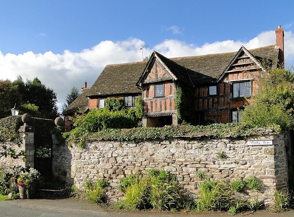



Historical names: Almali (Manor) | Elmelie (Manor)
Location: Almeley, Herefordshire
Places / associated places: Almeley, Herefordshire
Location & Extent
GPS Location & Recorded Land Areas
Representative GPS point: 52.15852, -2.97892
Identity: confirmed — The registry record for Almeley in Herefordshire matches the historical forms Elmelie and Almali and the documented medieval manor centred at Almeley village. The National Archives lead is an extent of the manor dated 1418, while medieval and later local historical sources identify Almeley as a manor associated with the Honour of Weobley.
Representative point: 52.15852, -2.97892
Basis: documented_manor_house — Almeley Manor, a surviving probably sixteenth-century manor house west of Almeley church, at OS grid reference SO3314051604 / approximately SO 331 515.
Point confidence: high
Boundary status: representative_point_only
Boundary period: 1418-1429, with earlier Domesday evidence from 1086
Boundary confidence: medium
Boundary basis: The 1418 National Archives record is an extent, but the accessible catalogue information does not provide a mapped perimeter. Historical evidence identifies the manor's scale and dispersed territorial interests rather than a defensible continuous boundary: Domesday records four hides and land for eight ploughs; a 1429 inquisition records 13 messuages, 580 acres of arable land, 80 acres of meadow, 40 acres of pasture, 25 acres of wood and rents in Almeley, Upcott, Kynardesley, Letton, Hereford, Holmere, Sheldewyk, Pipe and More. Because these holdings included geographically separate properties, neither the modern parish boundary nor a guessed polygon is an adequate substitute for the historical manorial extent.
Sources:
- The National Archives: Almeley manor record, TNA/MDR F279993: https://discovery.nationalarchives.gov.uk/details/c/F279993 — Registry record identifying the manor of Almeley in Herefordshire under authority/reference GB/NNAF/M303201.
- The National Archives: Extent of the manor of Almeley, 1418, E 142/80/7: https://discovery.nationalarchives.gov.uk/details/r/N16647022 — Existing record lead for the 1418 extent, confirming a manorial extent document but not exposing a usable boundary polygon in the accessible catalogue entry.
- Historic England: Almeley Manor, NHLE 1349938: https://historicengland.org.uk/listing/the-list/list-entry/1349938 — Documents the surviving Almeley Manor as a probably sixteenth-century house and establishes the precise historic building identity.
- Herefordshire Council: Almeley Conservation Area Appraisal: https://councillors.herefordshire.gov.uk/documents/s8793/10%20AlmeleyCA.pdf — States that Domesday Almeley, or Elmelei, was a manor held by Roger de Lacy, comprising approximately 300-400 acres of arable land, and discusses the medieval settlement and Almeley Manor.
- Herefordshire Archaeology and History: Almeley Castle and manor history: https://htt.herefordshire.gov.uk/herefordshires-past/the-medieval-period/castles/gazetteer-of-herefordshire-castles/parishes-a/almeley-castle/ — Records the 1086 manor of Almeley as four hides with land for eight ploughs and its connection with the de Lacy Honour of Weobley.
- Woolhope Naturalists' Field Club, Herefordshire Archaeology and History 64: https://www.woolhopeclub.org.uk/system/files/documents/han/han-64.pdf — Reports the 1429 inquisition for the manor of Almeley: 13 messuages, 580 acres arable, 80 acres meadow, 40 acres pasture, 25 acres wood and rents in Almeley and several other settlements.
- Geograph: Almeley Manor: https://www.geograph.org.uk/photo/2039998 — Provides a geotagged location for the documented manor house at approximately 52.15852, -2.97892 and identifies it as a sixteenth-century manor house west of the church.
Warnings / uncertainty:
- The historical manorial extent was not necessarily coterminous with Almeley parish or any modern administrative boundary.
- The surviving evidence indicates dispersed holdings across several settlements; a continuous polygon would require examination of the original 1418 extent, associated rentals, maps or parcel-level archival material.
- The representative coordinate identifies the surviving manor house, not the centre of the complete medieval landholding.
About the Manor
Historic manor associated with the parish of Almeley in Herefordshire.
Records & References
Sources and references mentioning this manor/title which are not necessarily conveyances or transfers.
1 record found · showing 1–1.
1418-1418: extent
Held by: The National Archives
Corrections / Challenges
Sign in to challenge or submit evidence against a recorded assertion.
JSON API
Machine-readable published manor data, including public images, mapped land areas, notes, rights, conveyances, relationships, records, source/document-library entries and public file links.
https://manorialregistry.com/index.php?rest_route=/mhr/v1/manor/almeleyPublic API access is currently disabled. Authorised API clients must use a private X-MHR-API-Key; currently only administrator keys are enabled.
Private source files, pending edits, moderation/admin information, user API keys and non-public import identifiers are not returned.