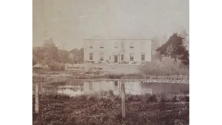



Historical names: Alainesmor (Manor) | Moralayn (Manor)
Location: Allensmore, Herefordshire
Places / associated places: Allensmore, Herefordshire
Location & Extent
GPS Location & Recorded Land Areas
Representative GPS point: 52.0141, -2.78
Identity: confirmed — The supplied registry record is securely identified with the Herefordshire manor recorded historically as Alainesmor, Moralayn, More Alani and Aleynesmore. The historical forms correspond to Allensmore in Herefordshire, and the associated medieval and early-modern court-roll references are consistent with this same manor and its later estate centre at Allensmore Court.
Representative point: 52.0141, -2.7800
Basis: documented_manor_house — Allensmore Court, the later manor house and estate centre, stood immediately east of Home Farmhouse in Allensmore. Historic England gives Home Farmhouse at NGR SO 46488 35363 and explicitly records the former Allensmore Court site immediately to its east. The point is therefore an approximate position for the demolished manor-house site, not the farmhouse itself.
Point confidence: medium
Boundary status: representative_point_only
Boundary period:
Boundary confidence: none
Boundary basis: The research establishes the manor's location and later estate centre but does not locate a reliable manor map, rental map, survey, or other source defining the historical manorial perimeter. The modern Allensmore parish boundary and the approximately 2,007-acre nineteenth-century parish area cannot safely be substituted for the medieval or later manor extent.
Sources:
- The National Archives: Allensmore manor record F279992: https://discovery.nationalarchives.gov.uk/details/c/F279992 — Registry authority record supplied for the exact manor, with primary name ALLENSMORE, alternative names Alainesmor and Moralayn, and location Allensmore, Herefordshire.
- Cambridge Dictionary of English Place-Names, entry for Allensmore: https://assets.cambridge.org/97805213/62092/excerpt/9780521362092_excerpt.pdf — Records the historical forms Aleinesmore 1220, Moralayn 1265 and Mora Alani c.1285-1346, and identifies the manor as held of the bishop of Hereford by Alan fitz Main.
- Herefordshire Place-Names: Allensmore: https://www.melocki.org.uk/places/A.html — Lists the forms Alainesmor 1265, Moralayn 1291, More Alani 1341 and Aleynesmore 1428, and connects the place with the medieval reclamation of part of Haywood by Alan de Plokenet.
- Herefordshire Through Time: Allensmore possible motte: https://htt.herefordshire.gov.uk/herefordshires-past/the-medieval-period/castles/gazetteer-of-herefordshire-castles/parishes-a/ — Identifies Allensmore as a bishopric manor in the historical record and gives a possible medieval manorial or defensive site at OS grid reference SO 4511 3588.
- Historic England: Home Farmhouse, Allensmore, list entry 1099729: https://historicengland.org.uk/listing/the-list/list-entry/1099729 — Provides the documented location of Home Farmhouse at NGR SO 46488 35363 and states that the site of Allensmore Court, demolished c.1957, lay immediately to the east. This supports the representative point for the former manor-house site.
- Allensmore Draft Neighbourhood Development Plan: https://allensmore.org.uk/wp-content/uploads/2020/01/AllensmoreReg14DraftNDPwithagreedchanges16Jul20191.pdf — Notes that the site of Allensmore Court was identified as an unregistered park and garden, and lists the nearby Home Farmhouse at NGR SO 46488 35363.
- Herefordshire Cathedral Library and Archives court-roll reference: 1339-1350: https://discovery.nationalarchives.gov.uk/details/r/N16646664 — One of the supplied medieval court-roll references associated with the Allensmore manor record; the series includes rolls with Kingstone and supports the continuity of the identified manor in the fourteenth century.
Warnings / uncertainty:
- The representative coordinates are approximate because Allensmore Court was demolished and the surviving authoritative coordinate is for the immediately adjacent Home Farmhouse.
- No historically defensible manorial boundary polygon was found. The modern parish boundary, listed-park extent, or nineteenth-century estate acreage should not be treated as the manor boundary.
- The possible motte at SO 4511 3588 is relevant historical evidence within Allensmore but is not proven to be the manor-house site or a boundary marker for the manor.
Records & References
Sources and references mentioning this manor/title which are not necessarily conveyances or transfers.
25 records found · showing 1–8.
1664-1664: court roll
Held by: Hereford Cathedral Library and Archives
Further information: NRA 6186
1658-1691: court rolls
Held by: Herefordshire Archive and Records Centre
Further information: NRA 33006 Hereford Diocese
1641-1641: court roll, with Kingstone
Held by: Hereford Cathedral Library and Archives
Further information: NRA 6186
1583-1583: court roll
Held by: Hereford Cathedral Library and Archives
Further information: NRA 6186
1580-1583: court rolls (4)
Held by: Hereford Cathedral Library and Archives
1575-1575: court roll
Held by: Hereford Cathedral Library and Archives
1561-1566: court rolls (5)
Held by: Hereford Cathedral Library and Archives
1558-1558: court roll (mutilated)
Held by: Hereford Cathedral Library and Archives
Corrections / Challenges
Sign in to challenge or submit evidence against a recorded assertion.
JSON API
Machine-readable published manor data, including public images, mapped land areas, notes, rights, conveyances, relationships, records, source/document-library entries and public file links.
https://manorialregistry.com/index.php?rest_route=/mhr/v1/manor/allensmorePublic API access is currently disabled. Authorised API clients must use a private X-MHR-API-Key; currently only administrator keys are enabled.
Private source files, pending edits, moderation/admin information, user API keys and non-public import identifiers are not returned.