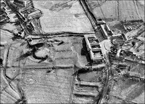



Location: Alderton, Northamptonshire
Places / associated places: Alderton, Northamptonshire
Location & Extent
GPS Location & Recorded Land Areas
Representative GPS point: 52.1163, -0.92256
Identity: confirmed — The registry record is securely identified with the historical manor of Alderton, Northamptonshire. The supplied TNA/MDR leads include a 1650 Parliamentary survey and successive rentals, surveys, terriers and accounts explicitly associated with Alderton and the Honour of Grafton. Independent historical and archaeological sources place the manor house and its associated manorial lands at Alderton, not at another same-named manor. Alderton was annexed to the Honour of Grafton in 1542.
Representative point: 52.11630, -0.92256
Basis: documented_manor_house — Approximate WGS84 conversion of Northamptonshire Historic Environment Record grid reference SP 7387 4696, identifying the documented site/platform of Alderton Manor House at the north-west extremity of Alderton village. Archaeological investigation identified foundations and the north-west corner of the former manor house in the Bramblewood House/Mull House area.
Point confidence: high
Boundary status: representative_point_only
Boundary period: Medieval to post-medieval manor; documented in the 1650 and 1660 surveys and later Honour of Grafton estate records
Boundary confidence: none
Boundary basis: The available web evidence establishes the manor-house site and confirms that the manor comprised agricultural land in Alderton, including open-field, meadow, orchard, garden and other holdings. However, no accessible manor-specific boundary plan or sufficiently explicit perimeter reconstruction was found. The modern civil parish, village, Honour of Grafton, or later Grafton Estate boundaries cannot safely be substituted for the historical manorial extent. The 1650 survey lead may contain the necessary parcel-level evidence, but its full geographic content was not available in the consulted sources.
Sources:
- National Archives Discovery: TNA/MDR record F278608: https://discovery.nationalarchives.gov.uk/details/c/F278608 — Registry record for Alderton Manor and the principal identification reference.
- Northamptonshire Historic Environment Record: Site of Alderton Manor House, 4745/4/1: https://her.northamptonshire.gov.uk/Monument/MNN24695 — Identifies the probable manor-house site at the north-west extremity of Alderton and gives grid reference SP 7387 4696; records archaeological evidence for the former manor house, gardens, fishponds and earlier motte.
- Historic England Archive record: Alderton Manor, BF107320: https://her.northamptonshire.gov.uk/Source/SNN116081/ — Records the Historic England plan of the manor-house site with adjacent ring castle.
- Grafton Estate: The Manor at Alderton: https://www.mkheritage.org.uk/grafton/Alderton/Alderton%20Manor.html — Provides historical identification of the Alderton manor house, its location at the north-west corner of the village, the 1582 rebuilding by William Gorges, later demolition, and references to the 1650/1660 surveys.
- Grafton Estate: Alderton History: https://www.mkheritage.org.uk/grafton/Alderton/Alderton%20History.html — Describes the historical manor, its annexation to the Honour of Grafton, the former manor house and Manor Farm, and the agricultural organization of the manorial lands.
- Historic England: Farm Buildings at Manor Farmhouse, Alderton, list entry 1040823: https://historicengland.org.uk/listing/the-list/list-entry/1040823 — Provides a corroborating modern location for the surviving Manor Farm complex associated with the former manor site, at NGR SP 74115 46786.
- National Archives Discovery: 1650 Parliamentary survey, E317/Northants/15: https://discovery.nationalarchives.gov.uk/details/r/N16466175 — Supplied registry research lead for the manor-specific 1650 survey, potentially relevant to reconstructing the historical territorial extent.
Warnings / uncertainty:
- The representative coordinate marks the documented historical manor-house site, not the centre of the entire manorial territory.
- No historically defensible manor-boundary polygon was returned.
- The civil parish and modern Honour of Grafton boundaries were not used as substitutes for the historical manor extent.
Records & References
Sources and references mentioning this manor/title which are not necessarily conveyances or transfers.
12 records found · showing 9–12.
1660-1660: survey, with other manors (Honour of Grafton)
Held by: The National Archives
1650-1650: survey (Parliamentary)
Held by: The National Archives
1634-1635: rental, with other manors (Honour of Grafton)
Held by: The National Archives
1477-1477: rental, with other manors
Held by: Northamptonshire Archives Service
Further information: NRA 23651 Knightley
Corrections / Challenges
Sign in to challenge or submit evidence against a recorded assertion.
JSON API
Machine-readable published manor data, including public images, mapped land areas, notes, rights, conveyances, relationships, records, source/document-library entries and public file links.
https://manorialregistry.com/index.php?rest_route=/mhr/v1/manor/alderton-manor-3Public API access is currently disabled. Authorised API clients must use a private X-MHR-API-Key; currently only administrator keys are enabled.
Private source files, pending edits, moderation/admin information, user API keys and non-public import identifiers are not returned.